Crunch Time
Redistricting is a process that is fundamental to our democracy. Redistricting has been happening (slowly and mostly quietly) for the last several months. I laid out the background, importance, and process of the Spokane County Redistricting Commission in this post back in March. Tomorrow, Tuesday, October 12, is the deadline to submit comments on the Spokane County Redistricting Committee’s draft maps.
Perhaps fifty to a hundred people in Spokane County seem pay much attention to the process of the county Redistricting. I think I understand why. Watching two people chosen by Republicans (Jim McDevitt and Robin Ball) and two chosen by Democrats (Natasha Hill and Brian McClatchey) figure out how to get three to one or four to zero agreement on the boundaries of five new Spokane County Commissioner districts seems an arcane exercise. What follows is my attempt to make sense out of what I saw. The opinions expressed are mine.
The commissioners got off to a slow start, unable to agree on the selection of a non-voting chair person, a disagreement that, by law, gave the choice to the existing county commissioners. That seemed like a bit of a conflict of interest, since the current county commissioners fought hard against the entire process. Finally, after the process dragged on, the current county commissioners chose Elaine Couture as the non-voting chairperson of the theoretically independent redistricting commission.
Early on, several people from county government attended the meetings, and it seemed the people from county government, perhaps with non-partisan intent, put forward a company, FLO Analytics, expert in Geographic Information Systems (GIS) and data analysis. The choice seemed logical at first, but friction between FLO and the four members of the Commission over timelines, budgets, and lack of responsiveness developed early and persisted. In the end it seemed that FLO wasn’t really up to the task, even though their fees consumed something like three quarters of the budget. The impression I acquired as an onlooker was that FLO possessed a lot of data but little or no data on election patterns—patterns which, after all, are the bedrock of this process. The back and forth with FLO and the Commission took up a lot of time that, in retrospect, might have been better spent.
The state law requiring this new redistricting process is detailed in RCW 36.32.053 and RCW 36.32.054, but some of the criteria for drawing the districts are set forth in RCW 29A.76.010, one part of which reads:
(4) The plan shall be consistent with the following criteria:
…(d) Population data may not be used for purposes of favoring or disfavoring any racial group or political party.
That is essentially a mandate against gerrymandering. One cannot avoid gerrymandering or the suspicion of gerrymandering by ignoring prior voting patterns—and it seemed that FLO was ill-equipped to provide or discuss that data.
Enter Dave’s Redistricting App, a free web-based application that substantially demystifies the process of redistricting by providing the data and tools to draw district lines and assess the level of fairness in the districts drawn. Read the wikipedia article for background. In contrast to the struggle the commissioners seemed to have with learning to work with FLO’s mapping program and expensive consulting, at least two of the commissioners mastered Dave’s Redistricting App on their own and used it in their own homework.
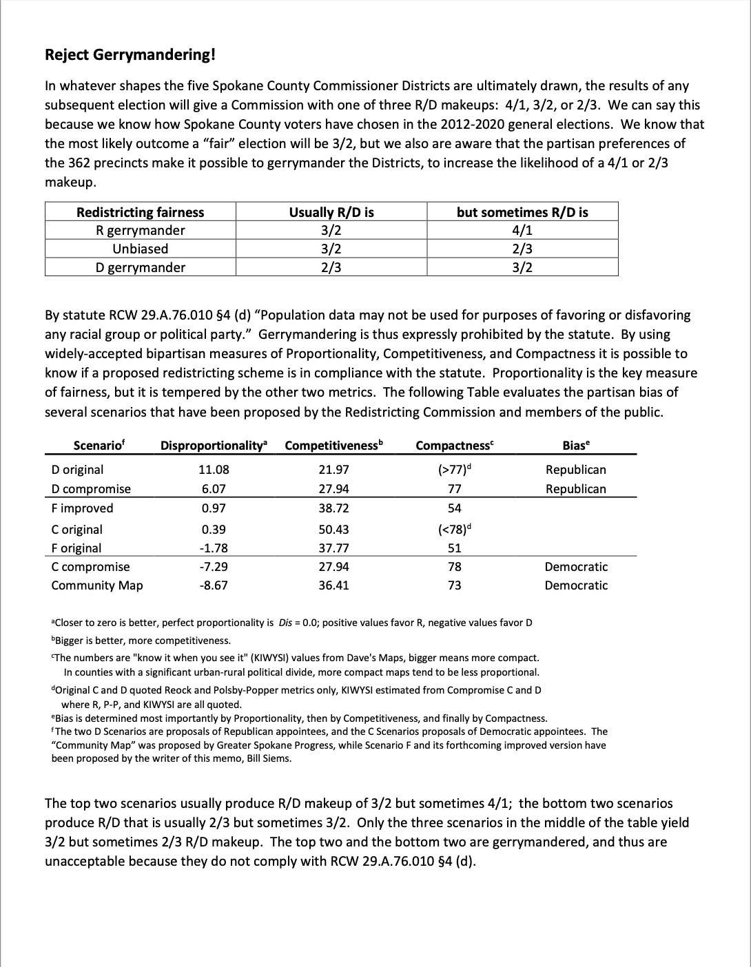
A friend of mine, Bill Siems, attended all or nearly all of the meetings and undertook to learn how to use Dave’s Redistricting App and used it rank the maps the commissioners and others proposed in terms of gerrymandering. The underlying assertion is based on the publicly available precinct voting patterns for the last many years. County records show that within Spokane County that of the votes cast those cast for Republicans average in the neighborhood of 52-55% of the total. That implies that, on average, any non-gerrymandered redistricting should yield 3Rs and 2Ds. That is the starting point for Bill’s explanation copied below with permission.
If, after digesting this, if you wish to lodge your input to the commissioners before the Tuesday deadline you can use the comment box at the bottom of this webpage:
https://www.redistrictspokaneco.com/
On that webpage you can also see (with some study), the two D and two C maps. The best I can tell, the two D maps were submitted by the Republican appointees and the two C maps by the Democratic appointees. The two maps designated F were designed by Mr. Siems. The Community Map is presented here.
Keep to the high ground,
Jerry
P.S. On a national basis Republican pioneered computerized gerrymandering with their REDMAP in 2010, succeeding in adjusting boundaries in several states that gave Republicans a House majority while garnering fewer votes. It seems entirely fair that Dave’s Redistricting App now empowers computer savvy citizens to assess, shed light, and counteract the potential for computerized gerrymandering. [That’s true at least in states where redistricting is either a non-partisan or a balanced partisan process (the latter is the case in Washington)]