Neighborhoods need your input
| Oct 19 |
In the heated atmosphere of the upcoming national, state, and county elections in November (at least in Washington State) it is tempting to put local governance mentally on the back burner. After all, City of Spokane elections for Mayor, City Council President, and City Council Members don’t happen until August and November of next year, 2023. However, important long term issues still can and do simmer on that back burner—a back burner I fear I have wrongly neglected. The City of Spokane Redistricting Board members were chosen last spring and had their first formal meeting on June 16. The Board held a Town Hall on July 20, at which just one citizen appeared, a representative of the non-partisan League of Women Voters of Spokane. Between August 2nd and 19th the Board held a “Thought Exchange” that garnered only 155 comments. Those comments emphasized two goals for the Board’s deliberations: 1) That the Board draw lines for the new City of Spokane Council Districts that correspond to Neighborhood Council boundaries (see below) and 2) That each Council District to contain a piece of downtown—since we all share downtown. Neither of these wishes was much respected by the Board in the map they are putting forward to the Council.
First, I think it is important to review the government structure of the City of Spokane. In 1999, twenty-one years ago, the City adopted the current “strong mayor” form of government. Spokane’s strong mayor system consists of an executive branch (the Mayor’s Office) under a mayor elected by citywide voting and a legislative branch (the “City Council”) with a Council President also elected citywide elected and six City Council members, two elected from each of three City Council districts. All eight City of Spokane elected officials are, nominally at least, non-partisan.
After each decennial census (2010, 2020) a redistricting board is formed to propose adjustments to the three council districts to allow for changes in population. This re-districting seems to come almost as an afterthought to other re-districting processes that readjust other (U.S. Congressional, state, and county) districts. Since the first municipal (city) elections affected by the changes aren’t held until two years after the census year, I suppose it seems reasonable that city council re-districting should come last. (There may also be a district border readjustment at each 5 year mark, depending on the perceived need.)
In 2000, around the same time the City of Spokane converted to a strong mayor system of government, the City also adopted the Neighborhood Councils Program “In order to foster communication between the citizens of Spokane and all facets of City government.” Each Neighborhood Councilsends a representative to the Community Assembly (found on the City website under “Official Commissions”), providing a neighborhood voice to City of Spokane government. Check out the map of Neighborhood Councils. (The map was an eyeopener for me. For years I’ve read in the Spokesman of this or that neighborhood and imagined a map location. The map revealed to me that my mental picture was often totally wrong. Can you confidently place the Riverside neighborhood, for example? I couldn’t.)
Just three of these Neighborhood Councils—East Central, West Hills, and Riverside—are currently split between two City Council Districts. The Neighborhood Councils are pretty much by definition “communities of interest”. Under RCW 29A.92.050:
To the extent feasible, the district boundaries shall coincide with existing recognized natural boundaries and shall, to the extent possible, preserve existing communities of related and mutual interest.
East Central, in particular, is a community of interest that suffered intentional geographic division when a path was cleared through the neighborhood for the building of I-90 beginning in the 1950s. This intentional division was (and is) perpetuated by City of Spokane City Council District borders that split East Central between District 1 (NE) and District 2 (South). As a consequence the voice of East Central is weakened. No City Council Member needs to listen as closely to the voice of East Central because East Central’s votes are divided between two City Council districts.
Between September 22 and October 2nd the Redistricting Board looked for more input in choosing from among fifteen maps they and others had offered up. The Board solicited rankings of the maps on an online Survey Monkey Survey. The Board logged just 287 responses, plus another roughly 30 emails (verbal statement by the Board Chair from the October 4 Board Meeting video). Survey Monkey results depend on awareness and motivation. Results can be overwhelmed by either a few folks filling out a survey multiple times (responses are anonymous) or by a highly motivated group logging in at a high rate. Even so, the two leading maps coming out from that survey were Map #1 “Minimal Changes with Shared Downtown” and Map #2 “Whole Neighborhood Council Boundaries with Shared Downtown”. (Here’s a map of the current City Council boundaries. Here is the Neighborhood Council Map, the same one linked.)
The clincher came at the October 4 Redistricting Board Meeting—a “Town Hall” (which you can watch here). Four maps were up for consideration, but only two were much discussed, #1 and #2 noted above. Over thirty people came to speak. Three spoke in favor of respecting Neighborhood Council boundary lines. Listening to all the others, it is immediately clear they were all raising the same talking points, often in the same order. If you take the time to listen to the video you will hear the “Talking Points” put forward by the SpokaneGOP (copied below in the P.P.S.) repeated over and over. Daniel Walters wrote in an article October 6th (it is worth clicking that link and reading Walters’ full article) :
…there was an active right-wing campaign to rally opposition to Zappone’s map [Map #2] and support for Map 1.
Note that Map #2 became “Zappone’s Map” in part thanks to Daniel Walters’ prior writing—and, in spite of the fact that while many people submitted maps to the Board, Map #2 had risen to a position near the top on its own merits of preserving Neighborhood Council boundary integrity. (No one harped on the fact that Map #1 was proposed by Jennifer Thomas, one of the three voting Board members, and, arguably, the one with a partisan axe to grind—See P.S. below.)
Daniel Walters attended the October 4 “Town Hall” of the Redistricting Board and reported on the biases in the comment period on a revealing Twitter thread.
Following that hijacked comment period, the three voting members of the Redistricting Board, with several notes of reluctance, voted 3-0 to put forward Map #1 (Jennifer Thomas’ map) to the City Council (next Monday, October 24th). Seen in retrospect the comment period was a shameful exercise in partisan politics.
Next Monday, October 24, at the City of Spokane City Council Meeting, the Redistricting Board will officially present its recommended map, Map #1, the “Minimal Changes” map, to the City Council for either approval or modification. Next Monday’s City Council Meeting is the last chance for the public to address this issue. Please send an email to your Council people in support of Map #2 (click here), the Neighborhood-Council-respecting map. Better, attend the comment period at the Council meeting and speak in favor of Map #2 (and against Map #1).
We should all have been paying attention sooner. We let the SpokaneGOP, along with its main financial backers, the builders and realtors, hijack the process (See P.S.)—and we hardly noticed.
Keep to the high ground,
Jerry
P.S. Jennifer Thomas: There are issues with the makeup of the City of Spokane Redistricting Board. The Board was composed of three voting members chosen by Mayor Woodward and approved by the City Council. Qualifications are laid out in Sections 59 and 60 of the City of Spokane’s City Charter. The qualifications for the City of Spokane Redistricting Board try to minimize partisan bias by proscribing lobbyists and recent active participants in political campaigns.
Please recall that Mayor Woodward was elected in 2019 with major monetary support from the Builders and Realtors. Jennifer Thomas, one of the three Redistricting Board Members put forward by Mayor Woodward, is the current Government Affairs Director for the Spokane Home Builders Association. Registered lobbyist? Not exactly, but certainly someone who may well have a partisan axe to grind. In addition, Ms. Thomas narrowly avoided the prohibition against a Redistricting Broad member “contribut[ing] to any political campaign of any candidate for local, state, or federal office while a member of the districting board”. Just four days before her appointment to the Redistricting Board was confirmed on March 21, 2022, Ms. Thomas contributed to City Councilman Michael Cathcart’s campaign to become County Commissioner, County Commissioner District 2. (When I last checked a few years ago only around ten percent of registered voters had ever contributed any amount to a political campaign.)
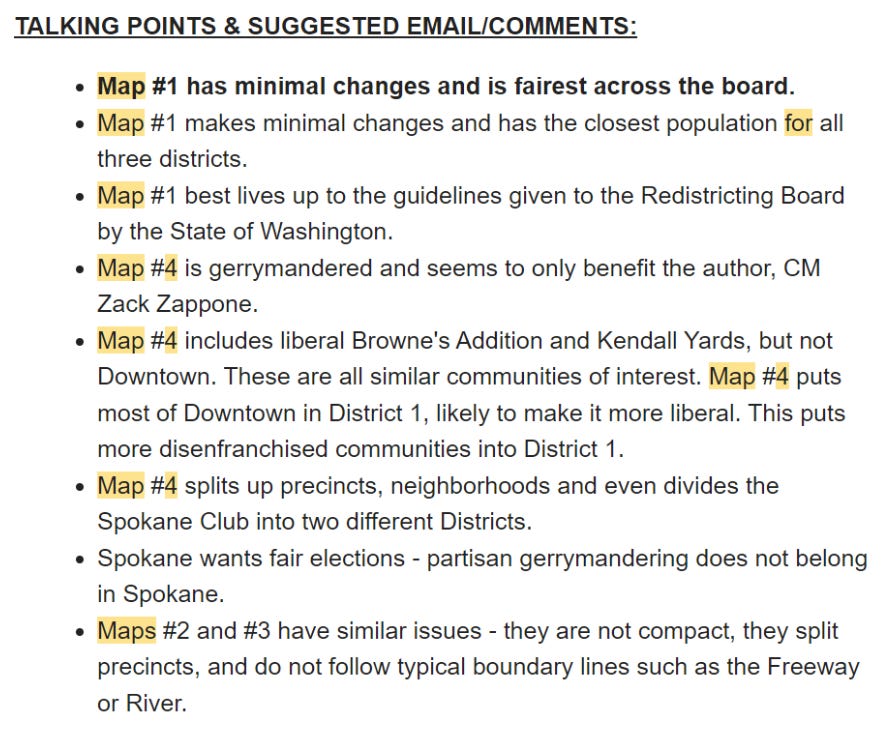
P.P.S. Below I’ve copied the SpokaneGOP call to action on Redistricting. (Note that they meant Map #2 when they wrote Map #4.) Of course, maintaining the integrity of the Neighborhood Council District boundaries is nowhere mentioned, in spite of importance of that concept in earlier input submitted to the Redistricting Board.
If you liked this post from Indivisible–The High Ground, why not share it?